|  | | 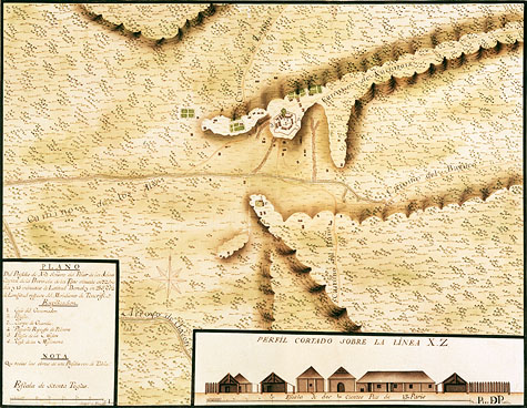 | | | Plano del Presidio de Nra Señora del Pilar de los Adaes Capital de la Provincia de los Tejas by Joseph de Urrutia, 1768 | | | Joseph de Urrutia was the principal engineer for the Rubí expedition of 1767-1768. The Rubí expedition inspected all the presidios of Northern New Spain, and 21 maps were drawn. The inspection at Los Adaes lasted 19 days, and the Urrutia map of Los Adaes is very detailed. The presidio and its buildings are drawn, and the mission area is shown. In addition, caminos, or roads are depicted, along with the individual houses and fenced gardens. The structures outside the presidio may resemble the types of structures observed in the 1870s image of the Caddo camp in Oklahoma. The small, square-shaped structures are associated with larger, rectangular structures. These small, square-shaped structures are never located to the west of the larger, rectangular structures. It is possible that the small, square-shaped structures represent domestic activity areas—cooking areas—and since the prevailing wind usually comes from the west; it was safest to locate these small, square-shaped structures either to the north, east, or south of the large rectangular-shaped structures. | | | Source: St. Pancras Map Library of the British Library: Additional MS.17.662.s Reproduction of images is prohibited | |
| |
|