GPS
Coordinates: Latitude: 31.823138 Longitude: -91.8155
Driving Directions:
— In Harrisonburg, from North Bushley Street, head toward
the Duty/Enterprise Ferry on La 124 West. Go 3.9 miles to
marker on left.
— From La 559 at the Duty/Enterprise Ferry, head south
on La 124. Go 12.5 miles to marker on right. |
| Number
of Mounds: 1 |
Number
of Visible Mounds: 1 |
| Summer
Viewing: Poor |
Winter
Viewing: Fair |
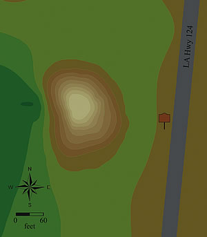 Alexander
Mound is a conical mound almost 60 feet west of La 124; it measures
about 101⁄2 feet high and 98 by 130 feet at its base. Overall,
the mound is in excellent condition. Coring has shown the mound
was constructed in two stages, with Stage 2 built soon after Stage
1. Radiocarbon dating of charcoal from beneath the mound suggests
that mound building began between 39 BC and AD 209 (Marksville
period). Artifacts found nearby are also of this age. Archaeologists
believe that Alexander Mound may be a southern extension of a
six-mound complex called J.W. King Place. Plowing has reduced
those mounds, north of Alexander Mound, and they are hard to see. Alexander
Mound is a conical mound almost 60 feet west of La 124; it measures
about 101⁄2 feet high and 98 by 130 feet at its base. Overall,
the mound is in excellent condition. Coring has shown the mound
was constructed in two stages, with Stage 2 built soon after Stage
1. Radiocarbon dating of charcoal from beneath the mound suggests
that mound building began between 39 BC and AD 209 (Marksville
period). Artifacts found nearby are also of this age. Archaeologists
believe that Alexander Mound may be a southern extension of a
six-mound complex called J.W. King Place. Plowing has reduced
those mounds, north of Alexander Mound, and they are hard to see.
|


