GPS
Coordinates: Latitude: 32.387527 Longitude: -91.478
Driving Directions:
— From I-20 (exit 153), head south on La 17. Go 4.3
miles to Martin Road; turn left. Go 1.4 miles to Frankie Loftin
Road; turn left. Go 0.2 mile to marker on left.
— From La 860, head north on La 17. Go 6.3 miles to
Martin Road; turn right. Go 1.4 miles to Frankie Loftin Road;
turn left. Go 0.2 mile to marker on left. |
| Number
of Mounds: 4 |
Number
of Visible Mounds: 3 |
| Summer
Viewing: Excellent |
Winter
Viewing: Excellent |
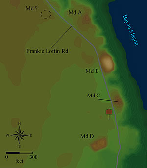 A
must-see. This large and complex site on the edge of Maçon
Ridge once may have contained as many as 13 mounds. Two large
mounds (Md. B and Md. D) are clearly visible from the marker.
Another very low mound (Md. C) is nearby, but it’s more
difficult to recognize. Three other possible mounds are to the
east; seven possible mounds to the west were leveled before their
status could be determined. The largest mound (Md. B) appears
to be conical and measures about 20 feet tall, although about
5 feet of mound fill has been removed from its top. It’s
almost 300 by 215 feet at the base. Soil sediments indicate it
was built in a single stage. The other large mound (Md. D) was
also built in one stage; it’s a platform mound, almost 11
feet tall and about 165 by 135 feet at the base. Although the
site was occupied as early as the Poverty Point period (1700–1000
BC), radiocarbon dating of charcoal from beneath Md. B and Md.
D shows the mounds date to the Coles Creek period (AD 700–1200). A
must-see. This large and complex site on the edge of Maçon
Ridge once may have contained as many as 13 mounds. Two large
mounds (Md. B and Md. D) are clearly visible from the marker.
Another very low mound (Md. C) is nearby, but it’s more
difficult to recognize. Three other possible mounds are to the
east; seven possible mounds to the west were leveled before their
status could be determined. The largest mound (Md. B) appears
to be conical and measures about 20 feet tall, although about
5 feet of mound fill has been removed from its top. It’s
almost 300 by 215 feet at the base. Soil sediments indicate it
was built in a single stage. The other large mound (Md. D) was
also built in one stage; it’s a platform mound, almost 11
feet tall and about 165 by 135 feet at the base. Although the
site was occupied as early as the Poverty Point period (1700–1000
BC), radiocarbon dating of charcoal from beneath Md. B and Md.
D shows the mounds date to the Coles Creek period (AD 700–1200).
|


