GPS
Coordinates: Latitude: 32.619138 Longitude: -91.410444
Driving Directions:
— From La 577 west of bridge, head west on La 134. Go
0.2 mile to Walnut Grove Lane, turn left; marker is on right.
— From La 17, head east on La 134. Go 4.4 miles to Walnut
Grove Lane, turn right; marker is on right. |
| Number
of Mounds: 1 |
Number
of Visible Mounds: 1 |
| Summer
Viewing: Excellent, but very distant |
Winter
Viewing: Excellent, but very distant |
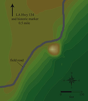 Lower
Jackson is the best-documented Middle Archaic mound on the Mounds
Trail. It’s a single conical mound on the edge of the Maçon
Ridge about 2 miles south of Poverty Point. Until the 1990s, it
was treated as part of that site because Poverty Point-style artifacts
were found near the mound and because it is aligned due south
of the largest mound at Poverty Point. Coring defined a single
stage of mound construction with extensive soil weathering. Charcoal
from below the mound dated to 3955–3655 BC, placing the
mound in the Middle Archaic period (>3000 BC). Some archaeologists
believe that the designers of Poverty Point incorporated Lower
Jackson into their grand layout. The mound is about 8 feet tall
and almost 130 feet in diameter at the base; portions of it were
removed in the 1970s and 1980s, so it’s only 70% intact.
A small historic cemetery on top helped prevent additional destruction. Lower
Jackson is the best-documented Middle Archaic mound on the Mounds
Trail. It’s a single conical mound on the edge of the Maçon
Ridge about 2 miles south of Poverty Point. Until the 1990s, it
was treated as part of that site because Poverty Point-style artifacts
were found near the mound and because it is aligned due south
of the largest mound at Poverty Point. Coring defined a single
stage of mound construction with extensive soil weathering. Charcoal
from below the mound dated to 3955–3655 BC, placing the
mound in the Middle Archaic period (>3000 BC). Some archaeologists
believe that the designers of Poverty Point incorporated Lower
Jackson into their grand layout. The mound is about 8 feet tall
and almost 130 feet in diameter at the base; portions of it were
removed in the 1970s and 1980s, so it’s only 70% intact.
A small historic cemetery on top helped prevent additional destruction.
|


