GPS
Coordinates: Latitude: 31.93468 Longitude: -91.4193
Driving Directions:
— From La 128, head south on La 573. Go 3.8 miles to
La 892; continue straight on La 892. Go 1.2 miles to La 3252
(not on state map); turn right. Go 2.2 miles to marker on
right. |
| Number
of Mounds: 4? |
Number
of Visible Mounds: 2 |
| Summer
Viewing: Fair |
Winter
Viewing: Good |
 Sundown
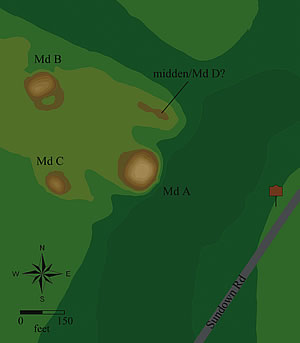
may be the oldest Coles Creek mound group on the Mounds Trail.
Its three confirmed mounds form a triangle on the west side of
Little Choctaw Bayou. The largest, closest to and visible from
the marker, is a platform mound (Md. A) 11 feet high; its base
measures about 190 by 180 feet, with a summit platform 60 feet
square. A second large platform mound (Md. B) is about 400 feet
to the northwest; it’s 8 feet tall, and measures 130 by
100 feet at its base, with its platform about 65 by 33 feet. The
third mound, behind the largest, is a 7-foot tall, dome-shaped
mound about 100 by 80 feet at the base. About 150 feet north of
the largest mound is what may be either a mound or a village midden
(refuse pile). The site was occupied before and during mound building,
and dates to AD 700–1200 (Coles Creek period). Sundown
may be the oldest Coles Creek mound group on the Mounds Trail.
Its three confirmed mounds form a triangle on the west side of
Little Choctaw Bayou. The largest, closest to and visible from
the marker, is a platform mound (Md. A) 11 feet high; its base
measures about 190 by 180 feet, with a summit platform 60 feet
square. A second large platform mound (Md. B) is about 400 feet
to the northwest; it’s 8 feet tall, and measures 130 by
100 feet at its base, with its platform about 65 by 33 feet. The
third mound, behind the largest, is a 7-foot tall, dome-shaped
mound about 100 by 80 feet at the base. About 150 feet north of
the largest mound is what may be either a mound or a village midden
(refuse pile). The site was occupied before and during mound building,
and dates to AD 700–1200 (Coles Creek period).
|


