
Time and Place
Poverty Point was built between 1700 B.C. and 1100 B.C. There was a lot going on around the rest of the world at this time. In Egypt, Queen Nefertiti and the boy pharaoh, Tutankhamen, ruled. In Britain, Stonehenge was being finished. In China, the Shang Dynasty was flourishing. In Mexico, the Olmec were rising to power. In India, the Rig Veda, the oldest of Hinduism's sacred books, was being written.
At the same time, most American Indians north of Mexico lived in small, mobile bands of hunters and gatherers. Things were different at Poverty Point. Although the people were hunters and gatherers, they lived year-round in a large community. They built earthworks and made tools and decorative objects with rocks and minerals brought from afar. Nearby sites, and even some more distant ones, from the same time period as Poverty Point reveal a strong cultural influence coming from Poverty Point.
Next
Back
The Poverty Point site (above) is located near Epps, Louisiana, in West Carroll Parish. Poverty Point was the “cultural capital” of the region (left). Other people in the region shared the Poverty Point culture, but they lived at smaller sites, built smaller mounds, and had fewer fancy artifacts than at Poverty Point.
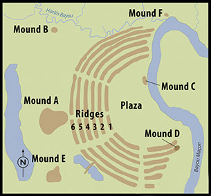

The site map above was created using LiDAR (Light Detection and Ranging), which is used to make highly detailed maps. This method of mapping, often done from an airplane or satellite, uses pulses of light to measure distances with great precision.